- 23 Chamelibagh, Dhaka-1217
- +88-02-9333543
- bfdrms@gmail.com

Thematic Maps
Refugee camps
On the left hand side of this map (see next page) are the names of states and districts where the Bangalee Refugee camps were situated (from April to November, 1971). During that period when the Bangalee Refugees stayed in 24 Parganas, Nadia, Murshidabad, Malda, Darjeeling and Koonchbihar districts of West Bengal of India and West Dinajpur district where the refugee camps sprang up, are dotted in the map. A numerous number of Bangalees took shelter in the camps of the states of Meghalaya, Assam and Tripura. The names of these camps are also mentioned. Just by the side of this column, a four-colour map of Bangladesh is shown in the middle column of the map and the position and place of the refugee camps are shown there. The distances among the situated camps around the map of Bangladesh can easily be viewed. The paths, roads, railway for communication are also given on the map to see how the movements of the general people, Pakistan army, Freedom Fighters of Bangladesh used these during those hazardous days. There are 6 photographs and a hand-painted picture in the map. These depict how the brute Pakistan army killed Bangalees, devasted land, culverts, bridges, railroads. These also show the agonised faces of the refugees who fled in fear for life from their beloved motherland leaving behind their sweet home and hearth. A real picture of the-then Bangladesh has found an eternal place in the map. In the right hand side of the map, there is a very important column in which a statistic of the Bangalees killed in genocide carried on by the Pakistan army during the War of Liberation and an account of Refugee camps. Under the shape of statistics, the data which are given will be of great help for the future generation and it is also very important for them to know these facts and figures. All the viewers of this column must know how the Pakistan army carried on genocide in conspiracy hatched by Yahia Khan and Zulfiqur Ali Bhutto of Pakistan on the fateful night of 25 March 1971 and also they should know about the situation under which Bangabandhu Sheikh Mujibur Rahman was compelled to declare independence of Bangladesh at the early hours of 26 March 1971. It is also there how Prime Minister of India Mrs Indira Gandhi supported on 31 March, 1971 the historic Mass-revolt of Bangladesh and War of Liberation and expressed her sorrows at the plight of the Bangalees. These important and necessary facts and figures are recorded in the right hand-side column of the map. At the bottom of this column there are accounts regarding refugee camps. The names, numbers of camps and refugees are mentioned in this column.
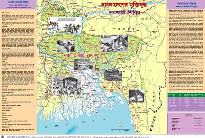
The Thematic map of Bangladesh Liberation War : Refugee Camps
Various information and statistics are clearly written in the map in a very lucid language on the one hand and on the other hand through this map a new vista of possibility to introduce about Liberation War is opened for the future generations attending the educational institutions of Bangladesh. The map may become an important instrument with which the real history of Liberation War and the-then reality can easily be placed before the people and the future generation. One will be able to find out one’s geographical boundaries of land as well as the refugee life of one’s forefathers. Till now there are living persons around us and they may recall the memories of those cursed days and nights whenever they strecth out this map before them.
Resistance Camps
the list. There are mention of Youth Camp Training Centre, the Headquarters of the camps, the women freedom fighters camp constructed during liberation war along with the other information regarding communication like roads, railways etc. in the map. The three rare photographs and an oilpaint of the Father of artists Joinul Abedin have increased its value, dimension and significance.
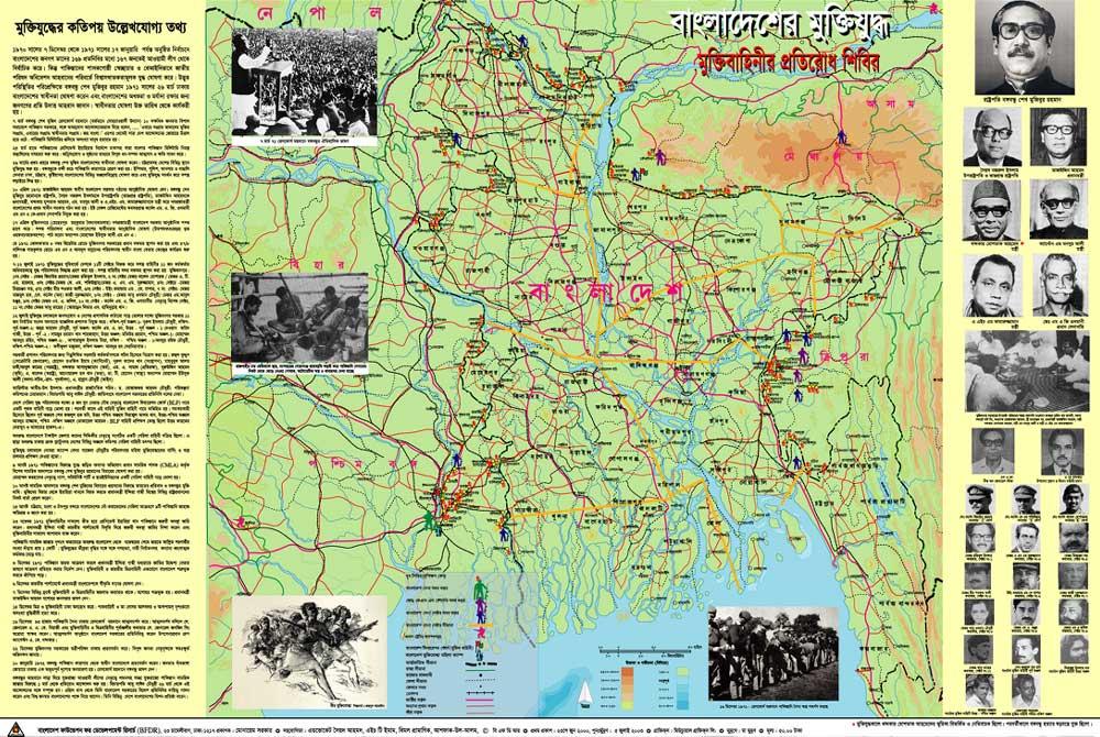
The Mujibnagar Government
In this way the important information of each month of the said period is included vividly in the map. Just below the title of the map the historical announcement of Bangabandhu, “Our struggle this time is our struggle for emancipation, struggle this time is the struggle of independence,” is cited in bold and bigger letters. This announcement inspired the Bangalees immensely with the dream of independence. On 17 April Free Bangladesh (Mujibnagar Government) Government was formed at Baidyanathtala of Meherpur. The headquarters of this Government was at Kolkata where all the activities used to have been done.
